Global Atmospheric Circulation - pressure belts and surface waves.
|
The global atmospheric circulation patterns that are evident in the Earth's atmosphere are a product of the differential heating of the Earth. Put more simply - it is hotter near the equator where the sun is directly overhead than the poles where the sun is nearer the horizon. Have a look at the slideshow on the right for a simple explanation.
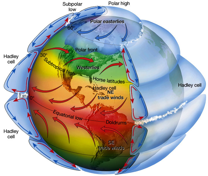
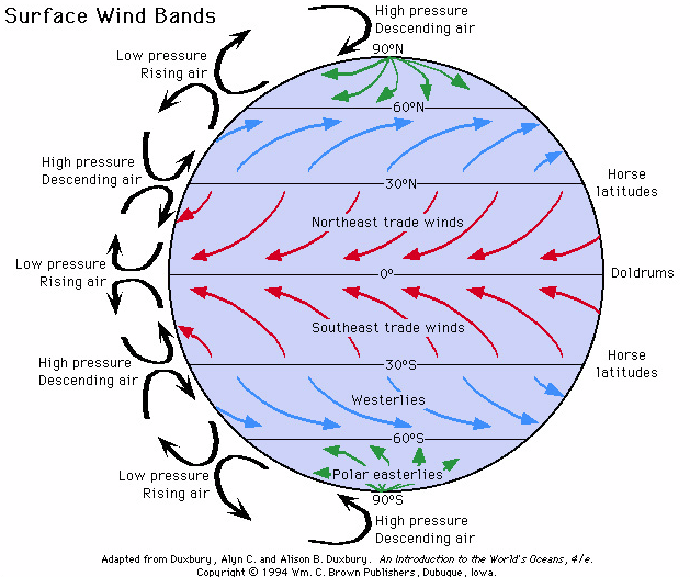
This difference in heating drives powerful convection currents - Hadley Cells and Ferral Cells. These help to even out the energy imbalance between the equator and the higher latitudes (higher latitudes mean nearer the poles). Look at the two images below and then scroll down to see if you can use them to help identify some of the patterns on the observations maps from Ventusky. |
|
|
|
 |
Global Temperature PatternsThe highest temperatures on Earth occur in the tropical regions. This is primarily due to the angle at which the sun reaches the Earth's surface at these latitudes.
The further you go north and south of the equator the colder it tends to get. The temperature is also influenced by landmasses. Typically landmasses vary more in temperature that the oceans. This is the reasons why much of Africa and northern Australia appear purple. Towards the polar regions the landmass also influences the temperature. Note how much colder the centre of Greenland is than the surrounding oceans. Rainfall patterns |
 |
Closely related to temperature is precipitation. Where there is significant heating there is more evaporation. More evaporation means more clouds and more rainfall.
In the map on the left the Inter-Tropical Convergence Zone is clearly visible along the equator. North and south of the equator it is possible to make out where there is descending air. This means the air warms and therefore moisture is held as gas - therefore no rainfall. Hurricane Nicole is also visible in the north Atlantic. It had previously been further south lashing Bermuda with 120 mph winds. Global Pressure Patterns
|
 |
Understanding pressure is critical to understanding how the atmosphere distributes heat from the equator to the poles. Air rises near the equator causes low pressure. - here the lime and yellow colours in the tropics. These air masses then move north and south of the equator and descend at around 30 degrees north and south. These form the high pressure bands that you see in red. Here the air is sinking. As it sinks, it warms so any moisture in the air is held as a gas. Therefore it cannot rain. This is the reason why there are many deserts at these latitudes - eg, the Sahara desert.
Hurricane Nicole in the Atlantic is visible as an area of very low pressure. Global Wind Patterns |
 |
Wind is closely related to pressure. Essentially wind is the movement of air particles from an area of high pressure to an area of lower pressure.
Influencing the wind is also the Coriolis effect. This is the influence that the rotation of the Earth has on air masses. It means that air masses spin off north and south of the equator in particular directions. It also means that in the tropics the general movement of the air is in a westerly direction. Further north and south from the equator the air moves in an easterly direction. This is particularly noticeable in the Southern Ocean - the famous Roaring Forties and Furious Fifties. |
